Halifax Regional Municipality, not including Musquodboit
Halifax/Dartmouth are the population centers for Nova Scotia, the major hospitals are located in this area as well as significant SAR/Coastguard resources.
Most locations are surrounded by public property, so please be respectful when visiting, and park in such a way that you don’t imped the local residents
or create a safety hazard.
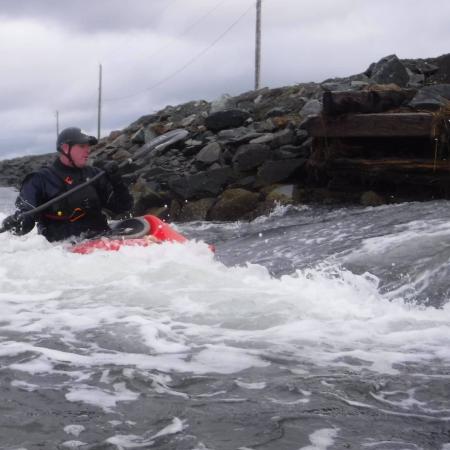
Lawrencetown’s point break has a few very nasty Riptides, especially on the ebb tide. If you find yourself caught in one of the rip tides swim, or paddle horizontally. I’ve personally been involved in the rescue of multiple people caught in these rips, so they should be taken very seriously. There are no sharp rocks, but at lower tide the waves can break against the rocks, which if you’ve flipped can result in some helmet/rock interaction.
Access
The best access for the point break is parking at what we call the “Stony Beach” parking lot, this is the parking lot before the hill to the Teahouse. This is not the parking lot with all of the buildings. At high tide you can put in right in front of the parking lot, at lower tides you may have to walk towards the point a bit.
Break Information
There are two primary breaks we surf, the best one is the point break, it’s also the bigger of the two. The point break lines up with the two windows at the top of the Tea House, which is the building on top of the bluff. There is another point break to surfers right if you position yourself about half-way out in relation to the second point this is where most of mid-sized waves break. The break-point changes based on surf conditions and directions. This break is best on a south swell.
Other Information
The point break is frequented by Board Surfers, we’ve so far maintained a very good relaitonship with them. Please maintain it, and follow the basic rules of surfing. If you run into trouble keep your cool and apologize, also explain how you catch waves, and figure out a way to not interfere with the surfers. Often I just start surfing the foam-pile, letting the surfers take the majority of the shoulder rides.
This wave/hole is relatively safe, surfers right gets shallow and is slightly sticky, and you could hit your head if you were to capsize.
The feature slowly becomes unsafe as it becomes shallow, the biggest risk is hitting the bottom.
Access
Please be respectful of the road, and the nearby residents. You can park at the intersection east of the bridge and walk to the wave see the Google Maps Min
Gauge
The feature starts forming around 2 hours and 20 min before low tide.
Media
4 - Sackville River
Low volume river run
Class: II/III+
Length: Wooded River Run
Location: Sackville NS
Character: Low volume, wooded, gun range
Gauge: —
Contributor: Karl Vollmer
Warning
If you continue past the takeout you will cross into a Department of Defense live fire range and may be subject
to fines, jail time and or death due to a stray bullet
Hazards
The Sackville river isn’t run very often, as such there’s limited beta on down wood and other obstructions. The river is also extremly flashy, and pushes lots of
wood into, and across the river. It is strongly suggested all blind corners are scouted by foot, as there are often over ten trees across the river creating river wide hazards at any one time.
This stream is very shallow, even when in full flood so there is a significant chance for rock contact if you capsize. It is only runnable during extreme rain events, as such it is very likely
that wood and or debris have washed down and created strainers. There are also points along the run that often have rope tied between the shorelines, depending on the water level the rope
may not be visible in a hole or wave. The entire run should be scouted before attempting.
Access
This very short run can be accessed via walking trail along the side of the road. There is enough space for two to three cars to park in a small gravel lot at the trailhead.
Gauge
This seems runable when the Sackville is at 1.75 or higher.
This is a curved stony beach with a nice sheltered small break about 100ft offshore, there is a rip that can be used to get out. The biggest hazard here
is surfers, as this is a popular location, and they use the wave differently than kayaks. Respect their rules, and be careful.
Access
This is a popular surfing spot, and as such parking might be complicated. Please avoid parking in anyones driveway or in an unsafe way along the road.
Surfers have damaged individuals cars who park on private property, so please be careful, and be friendly.
Gauge
Media
7 - Subdivision
Halifax
Subdivision point break
Class: SURF
Length: Park’n’Play
Location: Seaforth NS
Character: Sheltered SE Point Break
Gauge: Surf Forecast
Contributor: Karl Vollmer
Hazards
This is a remote point, that requires you to walk and then paddle out to. There is very limited visibility from the road / other houses, so if you do get in trouble it is unlikely that anyone will see you. In a short boat the swim can be 20-30min from the break back to shore. There are a few rips, and they change based on the wave direction, however the consistent one is surfers right of the point. This rip can extend quite a ways out, past the initial break.
Access
The point break can be accessed via a local trail along side the road. This is a narrow road, and there are houses along it so make sure that you park as far to the side as possible so that you don’t block the road. We currently have a good relationship with the locals, don’t spoil it.
Gauge
The secondary break at the point usually only goes off on larger swell days, it has good shelter from the west wind. Check here when the waves are at least 2m+ as reported at lawrencetown.